What’s the matter with NDVI Imagery?
NDVI is a basic formula that was developed for qualitative assessment of the presence and status of vegetation, specifically the presence of chlorophyll.

This post originally appeared on LinkedIn.
I was talking to an AgTech friend and naturally, I asked about remote sensing. His answer surprised me:
“Oh, we don’t have internal remote sensing practice, we just download NDVI maps online.”
I should not have been surprised, there are a lot of misconceptions about NDVI going around, including that it can be substitute for remote sensing expertise. Unfortunately, my friend’s company is totally missing out on when and how to use NDVI reliably and they also don’t seem to understand what it can and cannot tell them about the vegetation.
What is NDVI?
If you don’t use NDVI, or worse, if you do use it and still don’t know what it is, NDVI – Normalized Difference Vegetation Index – is a basic formula that was developed in the early 1970s by academic researchers – Rouse et al. (1974) and Tucker (1977) – for qualitative assessment of the presence and status of vegetation, specifically the presence of chlorophyll. It was developed to take advantage of the newly available multi-spectral data captured with Landsat-1, which was launched on July 23, 1972 and served mainly as a platform for obtaining information on resources like agricultural, forestry, geological, hydrological, oceanographical, and meteorological phenomena.
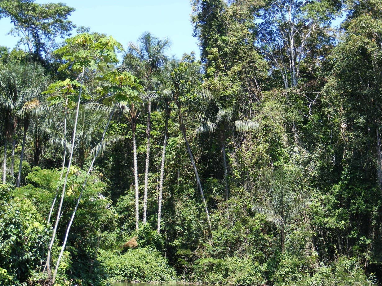
The formula uses reflectance values, the ratio of incident to reflected light, and looks something like this:
Image one
Where NIR and Red stand for the reflectance values in the Near Infrared and Red spectrum respectively.
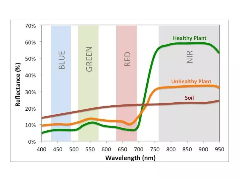
Image two
Where NIR and Red stand for the reflectance values in the Near Infrared and Red spectrum respectively.
Typical spectral signature of healthy and unhealthy vegetation and soil.
The problem with NDVI is humans
The problem with NDVI is not related to space imaging, physics, mathematics, or imagery analytics. The problem is that NDVI has become very popular, in part because of what people think NDVI can tell them about their fields, forests, and orchards. Unfortunately, what people think about NDVI isn’t always correct.
Here are a few examples:
1. Biomass: NDVI values calculated for a football field can reach over 0.85 which is almost the practical maximal value of NDVI, this is less than you would typically measure over a tropical forest.
2. Illegal logging: Tropical forests have complex structures, and in many cases, NDVI is not enough to track selective logging.
Even in cases where NDVI can spot areas where trees have been selectively removed, it is only briefly. As soon as the understory vegetation grows in, and this can happen quickly in tropical forests where most illegal logging takes place, NDVI can no longer distinguish between logged areas and trees.
Management zones in precision agriculture: NDVI tends to change rapidly during the season, reacting to irrigation, insect and disease damage, weeds, emergence issues, herbicide, fertilizer, etc.
Rapid index changes indicate that it is hard to rely on NDVI for establishing reliable management zones in precision agriculture, which should not change every day or so. (For more information see this article by Michael Dunn on Linkedin).
Those are the common misapplications of satellite NDVI data. Things get even more complex when you use NDVI data from drones. There are additional considerations related to the platform, sensor, duration of imaging, spatial and spectral resolution, calibration, and post-processing software.
But it’s not all doom and gloom
NDVI does have some useful applications. It is very good for a qualitative (relative) assessment of the current vegetation status and can be applied over large areas with satellites or aerial photography and to more specific areas with drones, so it can serve as a layer that can highlight areas with issues that need to be further investigated by other means.
NDVI is popular because of its simplicity. It is very easy to obtain NDVI maps from many imagery vendors (satellite, aerial and drone) who promote the use of NDVI as a value-add to their core product. You shouldn’t use NDVI just because you don’t know the alternatives or just because your imagery vendor says you should; you should use it when you know what it can really tell you about your vegetation and then decide if it’s the right tool for you.
What if I want to assess biomass or Leaf Area Index (LAI)?
These metrics require different sensing technologies than NDVI, and also more data analysis.
First, for biomass assessment, you need to combine longer wavelengths with multi-spectral data. Radar for example uses long radio waves and can penetrate deeper into the vegetation and interact with the entire structure of an object. This delivers advantages over NDVI for biomass estimation and detecting illegal logging.
One of the downsides of radar is that it’s not as easy to understand the results. Because radar reacts to different properties than visible color, it is harder to evaluate or validate the correctness of the data without a trained analyst or some good AI.
With passive sensing – like NDVI – your analysis is at the mercy of the time of day and the weather. If there’s no sunshine falling on your forest, there’s no reflectance to pick up for NDVI. By contrast, active remote sensing – like radar – is not sensitive to changes in sun illumination throughout the day, and only mildly sensitive to the presence of clouds, shadows, fog, or haze, and it can even operate in complete darkness. This can be very useful to model the dynamics of vegetation over time in a reliable way.
The last, and maybe most important key to understanding biomass and LAI is data analysis. If you really want to make sense of your data for business decisions, half-baked products, and ill-informed analysis will not cut it. You are going to need an analytics solution that can take all your data into consideration and deliver actionable insight.
The PlanetWatchers way
My opinions in this piece come not only from my years in the remote sensing field but also from my years as CTO and co-founder of PlanetWatchers, a geospatial intelligence startup. I’m really excited about what we’re doing at PlanetWatchers so I’d like to share a few thoughts about how we’re using geospatial data to deliver insight for our customers.
Specialists, not generalists. At PlanetWatchers, we aim to calibrate our algorithms to address the specific needs of our clients in precision forestry, agriculture, energy, and more. NDVI is a generalized metric – and a useful one – but natural resource managers demand industry-specific and actionable information.
Multi-source data. Unlike most imagery providers, PlanetWatchers can use or even combine data from different sources and providers. We combine multi-spectral data from satellites and field data like weather, topography, and soil condition to feed and calibrate our intelligence platform.
AI and last-mile analytics. To turn all this data into actionable intelligence, PlanetWatchers applies artificial intelligence algorithms that we develop to solve specific customer problems in natural resource management. The computing power needed to make this work is available in an elastic cloud infrastructure, making it fast and cost-effective. Finally, we present the data in a clear, easy-to-use dashboard for operational managers and business decision-makers.
All is not lost for my AgTech buddy. NDVI offers many benefits and it is simple to use if you have multi-spectral data available, but it is important to understand how to derive it in a professional way and what it can really tell you about your vegetation. NDVI alone is not usually enough to make good decisions but combined with data from other wavelengths, good algorithms, and last-mile analytics, it can help you derive more meaningful parameters that can ultimately help solve AgTech and Precision Forestry problems.
Do you love NDVI? Hate it? Reply to this post or drop me a line. I would be excited to continue the discussion about NDVI and its applications.
Focusing exclusively on crop insurance in North America, PlanetWatchers tells the story of every field saving our customers time and money by enhancing policy and claims validation.