Crop-free digital terrain model for precision agriculture
There exists a need for the generation of a timely DTM of recently harvested agricultural lands to support decision-making for land management practices.

Challenge:
Digital Terrain Models (DTMs) are extremely difficult to create on agricultural lands as a result of the short-term temporal changes of these lands. If a DTM is updated even once per year, there is most likely a crop growing on every hectare of land being mapped. The presence of crops would compromise the DTM accuracy and in many cases will make it impossible to create as bare ground is necessary for a reliable DTM creation. There exists a need for the generation of a timely DTM of recently harvested agricultural lands to support decision-making for land management practices.
There are approximately 1.5 billion hectares of agricultural land on Earth that are used for crop production. One of the challenges that growers are facing is how to optimize the output from their lands while minimizing the inputs as the global population is expected to greatly increase in the coming decades. In recent years, an increasing number of growers are relying on more accurate data to make decisions and take advantage of the benefits of precision agriculture. Many factors influence the productivity of these areas, such as nutrient availability, elevation, topography, and the timing of harvest operations.
There currently does not exist a reliably updated DTM for agricultural fields around the world that can be implemented in existing precision agriculture practices of the growers. A standard DTM showing up-to-date changes in topography, slope, and similar parameters, would provide important information to growers globally. Variable terrain scenarios may require different land preparation, crop practices, amounts of nutrients, and irrigation measures to be implemented to ensure yields are optimized. An accurate DTM would allow growers to optimize their yields and reduce the hectares lost to soil erosion each year. PlanetWatchers worked with a large sugarcane company with many hectares of distributed fields in Brazil as they required a more up-to-date and reliable DTM for agricultural decision-making.
Solution and Results:
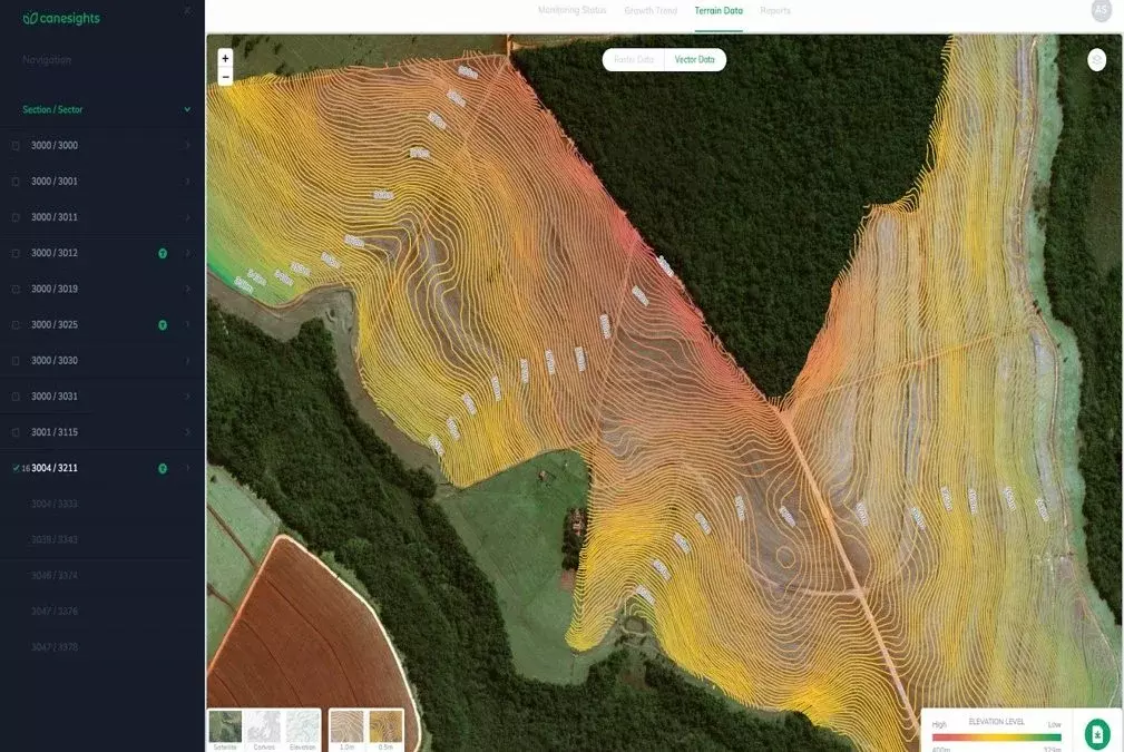
Radar imagery was used to successfully create DTMs for post-harvest agricultural lands that had not previously existed. The PlanetWatchers DTM solution utilizes synthetic-aperture radar (SAR) imagery from TerraSAR-X to create high accuracy DTMs for post-harvest agricultural fields. The technique uses precise repeat pass interferometric SAR (InSAR) analysis. SAR imagery can deliver DTM information following harvest events, regardless of cloud cover or fog. SAR imagery is also extremely sensitive to the growth of crops so it can be useful in determining which fields are fallow and which are still growing crops. The developed service involves scanning the area of interest for the presence of crops with each new image refresh, as well as identifying areas with fallow land to process and generate a unique crop-free DTM. The resulting DTM is capable of highlighting terrain differences as small as a couple of centimeters.
Benefits:
PlanetWatchers’ DTMs immediately following harvest events on agricultural lands provide more accurate and timely information (which was previously not available) for growers to leverage as part of their precision agriculture land management and ultimately reduce risks, and costs and maximize farmland productivity. Having a DTM that can be generated over millions of crop-free hectares can now assist growers with nutrient inputs, soil erosion calculations, yield predictions, and other important metrics for aiding decision-making.
A changing climate has led to increased instances of floods, droughts, and changes in the phenology of crops, which can lead to a 29% decrease in yields. As the global population is expected to grow by one billion people by 2030, there is intense demand to increase yields on existing agricultural lands. An accurate and timely DTM is one of the many building blocks in ensuring that there is enough food for the future.
Additional benefits include:
1. All-weather analysis guarantees the successful creation of DTMs within a short time window
2. Previously unavailable dataset for growers or consultants
3. Supports integration as part of the existing precision agriculture practices
4. Better decision-making to increase yield/productivity and reduce costs
5. Cost-effective solution compared to aircraft or drones
The PlanetWatchers DTM can be applied to agricultural fields all over the world and aid with preventing losses in yields as well as reducing the use of fertilizers and environmental damage by reliably mapping the terrain.
Applicability:
The DTMs created by PlanetWatchers can be applied to agricultural fields in locations all over the world and in any weather conditions, so even short periods of fallow land can be captured. The terrain data can help minimize the chemicals and fertilizers used and to maximize yields for a growing global population. Other areas of applications include forestry, energy production, insurance, and more. For more information about using satellite imagery for your analytics or to learn about PlanetWatchers, please email us at [email protected].
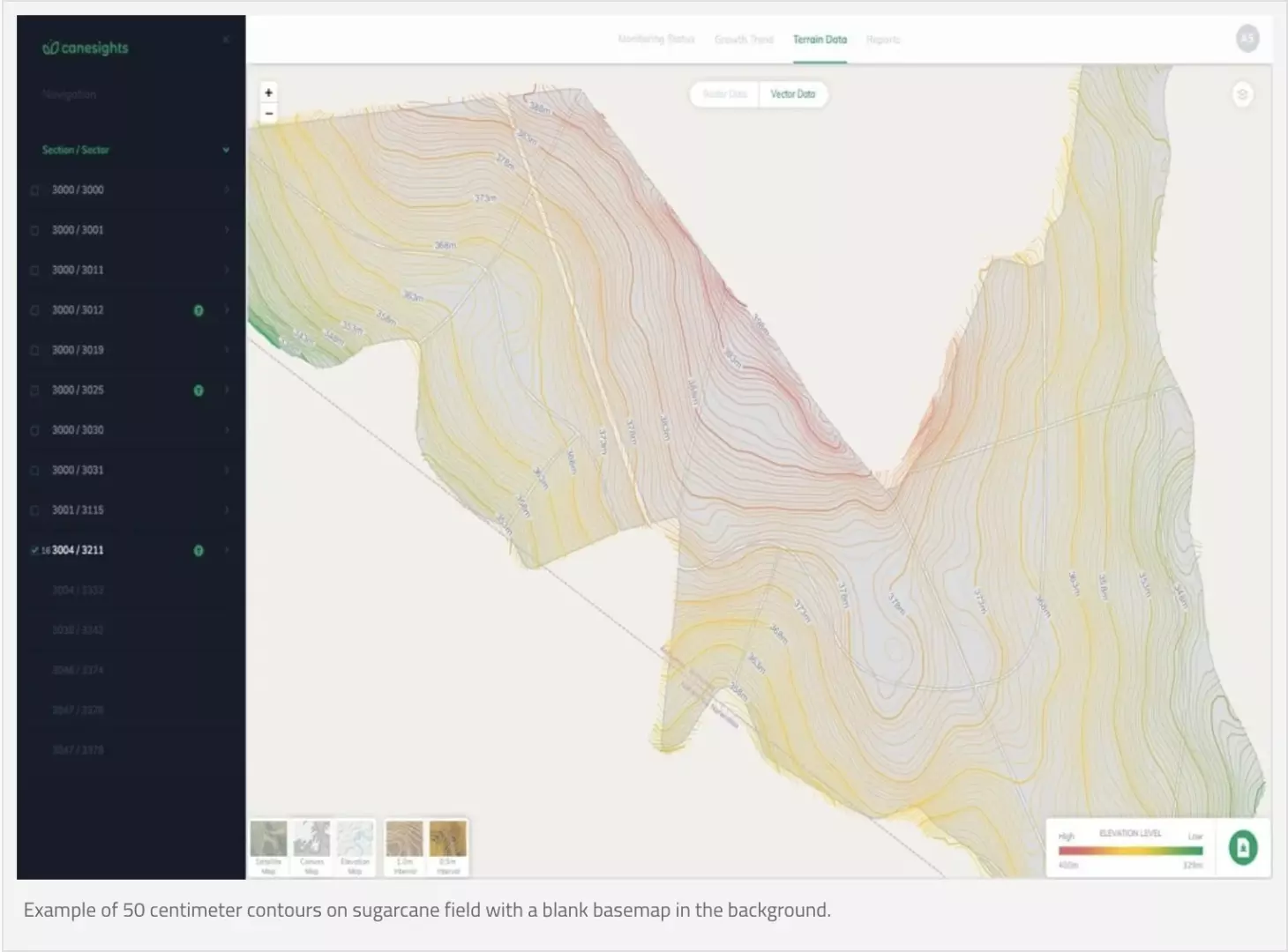
Example of 50 cm contours on sugarcane field with a blank basemap in the background.
Focusing exclusively on crop insurance in North America, PlanetWatchers tells the story of every field saving our customers time and money by enhancing policy and claims validation.