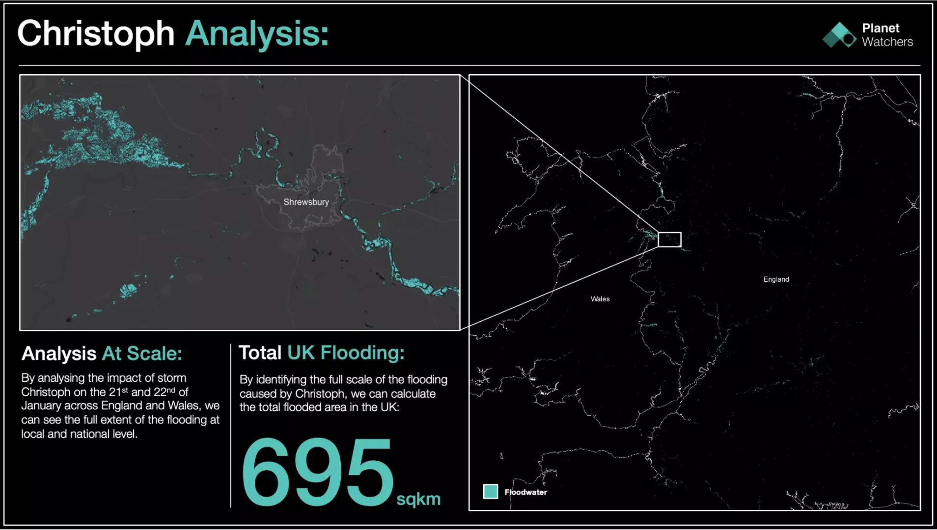
Storm Christoph: Over 695 sq. km of flooding sweeps across the UK
Beginning on 20th January, the storm brought high winds and the equivalent of 2 months’ usual rainfall in just 2.5 days.

Storm Christoph made a large-scale impact over 2-3 days across many parts of the UK. Beginning on 20th January, the storm brought high winds and the equivalent of 2 months’ usual rainfall in just 2.5 days. The vast amount of rainwater caused over 200 flood warnings to be put in place across many parts of the UK, in particular central and northern England and Wales.
Large rivers such as the River Severn, The River Trent, The River Don, and The River Aire that flow through many counties in these areas, burst their banks. Thousands of people were asked to evacuate their homes in Wales, Manchester, and Merseyside as flood levels became a danger to life.
By analyzing the impact of storm Christoph on the 21st and 22nd of January across England and Wales, we can see the full extent of the flooding at local and national levels.
Analysis on this scale would normally take weeks to collate, with the worst affected areas requiring immediate attention for disaster response and preparation against future events. Storm Christoph was the 9th named event in the European windstorm season (20-21).
At PlanetWatchers, we were able to use SAR data taken from Sentinel 1 to asses the entire area in under an hour.
Using SAR analysis and highly efficient algorithms we are able to quickly see the extent of the damage using change detection before and after the storm.
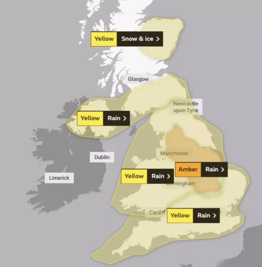
The Met Office issued flood warnings on 18th January 2021 as Storm Christoph approached. (image used from the Met Office)
Due to weather warnings issued by The Met Office in advance and flood warnings then issued on 18th January, the UK was braced for the impact, particularly in renowned areas of flooding from previous events.
Members of staff from our UK office were on standby to take stock of the flooding from the ground whilst our developers were busy analyzing the data from above.
In November 2020 The River Don in Doncaster burst its banks causing devastating flooding to houses within the Bentley and Fishlake areas of North Doncaster. Over 500 houses were flooded and 1000 evacuated causing Doncaster Council to take drastic action to prevent another event of this scale.
We did see some flooding from the River Don burst its banks yet again due to the excess rainfall from storm Christophe last week. Thankfully nowhere near as devastating, causing flooding mainly to farmland and flood plain.
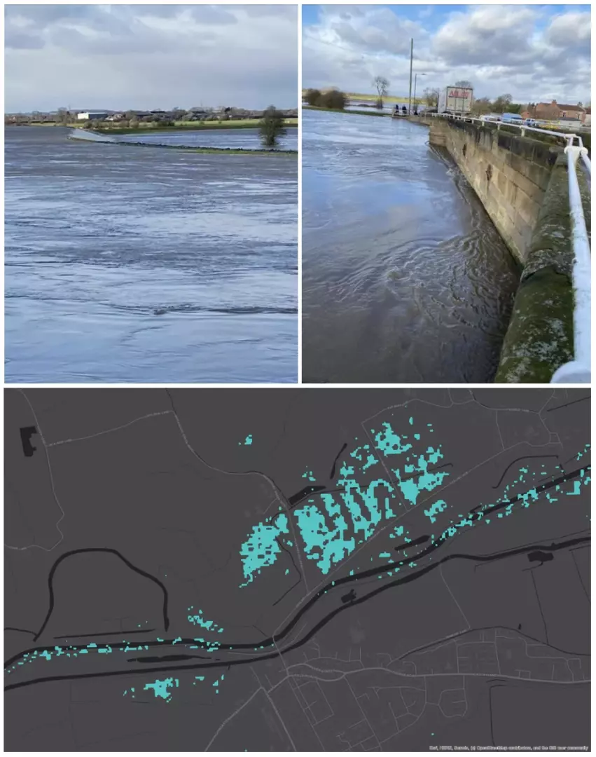
Flood map of The River Don near Stainforth, Doncaster, South Yorkshire taken on 21st January after Storm Christoph. (SAR data provided from Sentinel-1 satellite (contains Copernicus data 2021)
The River Trent is the 3rd longest river in the UK passing through Staffordshire, Derbyshire, Nottinghamshire, and Yorkshire. The Trent can often be prone to causing flooding in high-risk areas. We managed to get some photos in Derbyshire where you can see the expanse of its broken banks, flooding over into farmland. Our SAR analysis clearly shows the full extent of its flooding around South Derbyshire as it flows into Nottinghamshire.
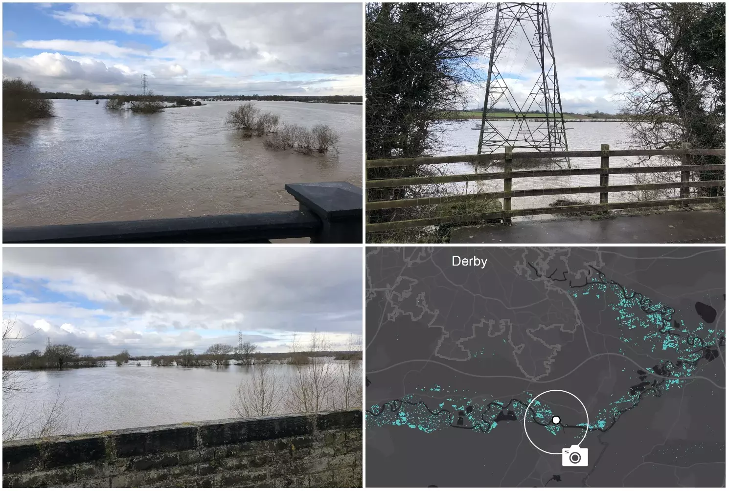
River Trent flooding over farmland in South Derbyshire, as a result of heavy rainfall from Storm Christoph.
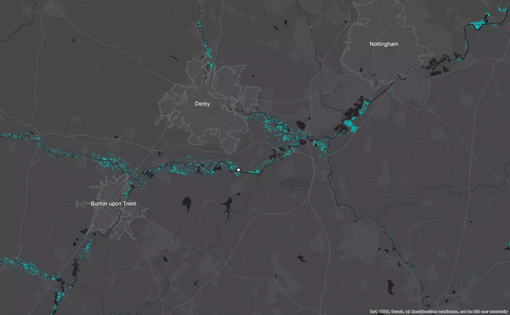
Zoom out flood map of River Trent flooding as a result of heavy rainfall from Storm Christoph.
Finally, Worcestershire was also an area greatly hit by flooding due to the River Severn breaking its banks and causing many road closures and disruptions. We didn’t manage to get any photos on the ground but we did capture a large-scale extent of the area.
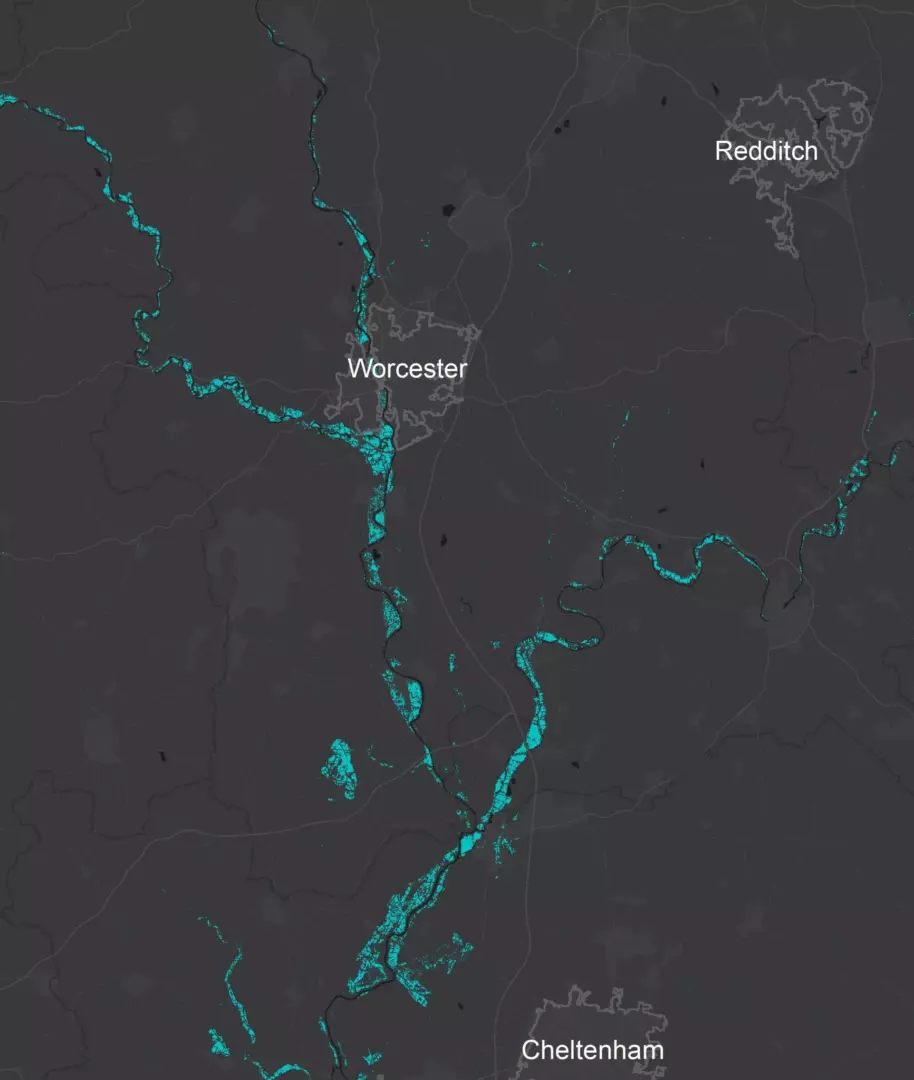
Damage map showing the affected region of Worcester.
The benefits of SAR mean that we are able to achieve accurate, large-scale imagery at speed regardless of weather conditions. This is perfect during storms and can be very beneficial should a disaster strike.
Our thoughts are of course with anyone who unfortunately is suffering as a result of the flooding caused by Storm Christoph.
Focusing exclusively on crop insurance in North America, PlanetWatchers tells the story of every field saving our customers time and money by enhancing policy and claims validation.